India Monsoon 2926: 64% rainfall deficit sparks alarm; whats causing the sudden pause? Explained
India's southwest monsoon has hit a pause. IMD reports a 64% rainfall deficit, just 19.2 mm received against 53.7 mm normal (June 4–15). Know why westerly jet stream disruption is suppressing rain across central and southern India
India monsoon update: India's southwest monsoon has slowed down significantly after making an early advance into several parts of the country. Large areas of central, southern and eastern India are witnessing a sharp decline in rainfall activity, raising concerns among farmers and weather watchers.
According to the India Meteorological Department (IMD), the country received only 19.2 mm of rainfall between June 4 and June 15, against the normal average of 53.7 mm. This has resulted in a nationwide rainfall deficit of 64%.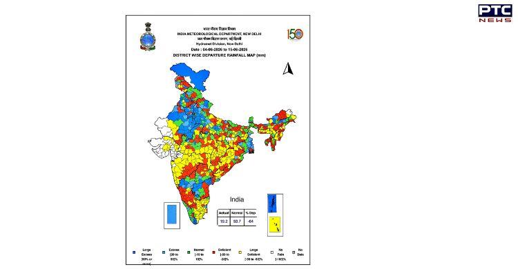
Large parts of India facing rainfall shortfall
The latest rainfall data shows that many regions are receiving far less rain than expected for this time of the year. Areas across central India, the southern peninsula and parts of eastern India are experiencing deficient rainfall.
The IMD's rainfall departure map highlights widespread shortages, with several states recording rainfall well below normal levels.
Satellite images show weak monsoon activity
Recent satellite images captured by INSAT-3DS on June 15 reveal a noticeable lack of cloud cover over much of peninsular and central India.
Normally, an active monsoon creates a vast blanket of clouds across the country. However, current images show clearer skies over many regions. Most cloud activity is concentrated over the Himalayan region, northeastern states and areas north of the Indo-Gangetic plains.
Weather experts have also observed that the Arabian Sea branch of the monsoon appears weak and fragmented.
What is causing monsoon slowdown?
Meteorologists say the slowdown is not due to a shortage of moisture over the Arabian Sea or the Bay of Bengal. Instead, the problem lies in atmospheric conditions several km above the Earth's surface.
A key factor behind the weak rainfall is the unusual position of the westerly jet stream, a fast-moving band of winds in the upper atmosphere. This jet stream has shifted farther south than it usually does during the monsoon season.
Upper-level winds affecting rainfall formation
The southward shift of the westerly jet stream is interfering with the easterly jet stream, which plays a crucial role in supporting monsoon circulation over India.
Under normal conditions, the easterly jet helps air rise and promotes the formation of rain-bearing clouds. However, stronger westerly winds are currently disrupting this process.
As a result, cloud development and rainfall have been suppressed across large parts of the country despite sufficient moisture being available.
Monsoon has advanced, but rainfall remains weak
Although the monsoon has progressed into parts of Karnataka, Telangana, Andhra Pradesh, Maharashtra and central India, the expected widespread rainfall has not materialised.
Weather experts describe the current situation as a temporary "monsoon pause", caused mainly by atmospheric conditions rather than ocean-related factors.
Rainfall activity likely to improve
Forecast models indicate that rainfall activity may gradually pick up later this week. Meteorologists expect the upper-air wind pattern to weaken, allowing the monsoon system to reorganise and strengthen.
Until then, many regions across India may continue to experience below-normal rainfall while waiting for the monsoon to regain momentum.